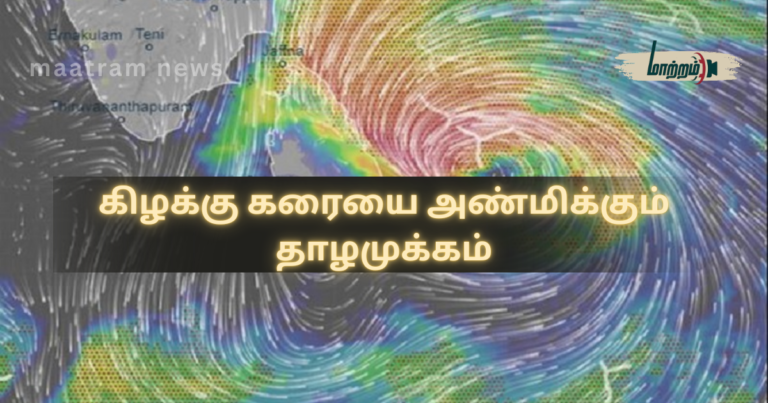
Low-Pressure System Approaching the Eastern Coast இலங்கையின் தென்கிழக்கு வங்காள விரிகுடாவுக்கு மேலாகவுள்ள வளிமண்டலத்தில் ஏற்பட்டுள்ள தாழமுக்கமானது, பொத்துவிலில் இருந்து 490 கிலோமீற்றர் தொலைவில் நிலைகொண்டுள்ளது.
இந்த தாழமுக்கமானது, எதிர்வரும் 24 மணித்தியாலங்களுக்குள் கிழக்கு கரையை அண்மிக்கக்கூடும் என வளிமண்டலவியல் திணைக்களம் எதிர்வு கூறியுள்ளது.
வளிமண்டவியல் திணைக்களத்தினால் இன்று அதிகாலை 05.30 க்கு இற்றைப்படுத்தப்பட்ட அறிவிப்பில் இந்த எச்சரிக்கை விடுக்கப்பட்டுள்ளது.
அதன்படி, குறித்த தாழமுக்க நிலையானது அடுத்த 12 மணித்தியாலங்களில் மேலும் வலுவடையக்கூடும் என எதிர்பார்க்கப்படுகிறது.
இதன் காரணமாக வடக்கு, வடமத்திய, கிழக்கு, ஊவா, மத்திய மற்றும் தென் மாகாணங்களின் பல பகுதிகளில் இடியுடன் கூடிய பலத்த மழை பெய்யக்கூடும் என எதிர்வு கூறப்பட்டுள்ளது.
அத்துடன், கிழக்கு மற்றும் ஊவா மாகாணங்களில் 100 மில்லிமீற்றர் வரையான பலத்த மழைவீழ்ச்சி பதிவாகக்கூடும் எனவும் அறிவிக்கப்பட்டுள்ளது.
மத்திய மலைநாட்டின் கிழக்கு சரிவுப் பகுதிகளிலும், வடக்கு, வடமத்திய, வடமேல், கிழக்கு மாகாணங்களிலும் ஹம்பாந்தோட்டை, கம்பஹா, மொனராகலை மற்றும் கொழும்பு மாவட்டங்களிலும் மணித்தியாலத்திற்கு 50 முதல் 60 கிலோமீற்றர் வேகத்தில் காற்று வீசக்கூடும் எனத் தெரிவிக்கப்பட்டுள்ளது.
இதேவேளை, மறு அறிவித்தல் வழங்கப்படும் வரை நாட்டை சூழவுள்ள கடற்பிராந்தியங்களை பயன்படுத்த வேண்டாம் என எச்சரிக்கை விடுக்கப்பட்டுள்ளது.
மன்னார் முதல், காங்கேசன்துறை, திருகோணமலை, பொத்துவில் மற்றும் ஹம்பாந்தோட்டை ஊடாக காலி வரையான கரையோரங்களை அண்மித்த கடற்பிராந்தியங்களில் இடியுடன் கூடிய மழை பெய்வதுடன், பலத்த காற்றும் வீசக்கூடும் என அறிவிக்கப்பட்டுள்ளது.
இதனால் கடற்றொழிலாளர்களும், கடற்படையினரும் மிகுந்த அவதானத்துடன் செயற்பட வேண்டும் என வளிமண்டலவியல் திணைக்களம் தெரிவித்துள்ளது.
மேலதிக தகவல்களுக்கு மாற்றம் செய்திகள் இணையத்தளத்தினுள் பிரவேசியுங்கள்.
மேலதிக தகவல்களை உடனுக்குடன் பெற்றுக்கொள்ள மாற்றம் செய்திகள் முகநூல் பக்கத்தை பின்தொடரவும்.
Low-Pressure System Approaching the Eastern Coast
A low-pressure system that has formed over the atmosphere above the southeastern Bay of Bengal is currently located about 490 kilometers from Pottuvil.
According to the Department of Meteorology, this low-pressure system may approach the eastern coast of Sri Lanka within the next 24 hours.
This warning was issued in an updated advisory released by the Department of Meteorology at 5.30 a.m. today.
It is further expected that the low-pressure system may intensify during the next 12 hours.
As a result, heavy thundershowers are likely to occur in many areas of the Northern, North Central, Eastern, Uva, Central, and Southern Provinces.
In addition, very heavy rainfall of up to 100 millimeters may be recorded in parts of the Eastern and Uva Provinces.
Strong winds with speeds of 50 to 60 kilometers per hour may occur in the eastern slopes of the central highlands, as well as in the Northern, North Central, North Western, and Eastern Provinces, and in the districts of Hambantota, Gampaha, Monaragala, and Colombo.
Meanwhile, the public has been advised not to engage in activities in the surrounding sea areas until further notice.
Showers accompanied by thunder and strong winds are also expected in the sea areas adjacent to the coastal belt from Mannar through Kankesanthurai, Trincomalee, Pottuvil, Hambantota, up to Galle.
The Department of Meteorology has urged fishermen and naval personnel to remain extremely vigilant.