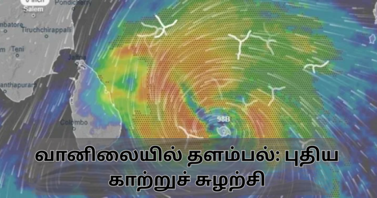
வங்காள விரிகுடாவில் இலங்கைக்கு தென்கிழக்காக புதிய காற்றுச் சுழற்சி ஒன்று உருவாகியுள்ளது. இது தற்போது உகந்தையில் இருந்து 408 கி.மீ. தென்கிழக்காக அமைவு பெற்றுள்ளது.
+++++++++++++++++++++++++++++++++++++
அதேவேளை இலங்கையின் தென் பகுதியை மையம் கொண்டு கீழ் வளிமண்டல தளம்பல் நிலை ஒன்றும் உருவாகியுள்ளது.
+++++++++++++++++++++++++++++++++++++
இதன் காரணமாக இன்று நள்ளிரவு அல்லது நாளை அதிகாலை முதல்(16.12.2025), வடக்கு, கிழக்கு, மத்திய, ஊவா, தெற்கு, வடமத்திய மாகாணங்களுக்கு மிதமானது முதல் கனமானது வரை மழை கிடைக்கும் வாய்ப்புள்ளது. ஒரு சில இடங்களில் மிகக் கனமழையையும் கிடைக்கும் வாய்ப்புள்ளது.
இம்மழை எதிர்வரும் 19.12.2025 வரை தொடரும் வாய்ப்புள்ளது.
இந்த மழை நாளை மறுதினம் (17.12.2025) நாட்டின் பெரும்பாலான பகுதிகளுக்கு கிடைக்கும் வாய்ப்புள்ளது. குறிப்பாக வடக்கு, கிழக்கு, ஊவா, மத்திய, வடமத்திய, சப்ரகமுவ மற்றும் மேற்கு மாகாணங்களின் பல பகுதிகளுக்கும் எதிர்வரும் 17.12.2025 அன்று கன மழை கிடைக்கும் வாய்ப்புள்ளது.
அதேவேளை நாளை முதல் (16.12.2025) வடக்கு, கிழக்கு, ஊவா, மற்றும் தென் மாகாணங்களின் கரையோரப் பகுதிகளுக்கு சற்று பலமான காற்று வீசும் வாய்ப்புள்ளது. குறிப்பாக மணிக்கு 30- 40 கி.மீ. வேகத்தில் காற்று வீசும் என எதிர்பார்க்கப்படுகிறது.
***********************************************
1. இந்தக் காற்றுச் சுழற்சி இலங்கைக்கு தென்கிழக்காக நிலவுவதாலும்….
2. இக்காற்றுச்சுழற்சி மேற்கு, வடமேற்கு திசை நோக்கி நகரும் என்பதனாலும்…..
3. இலங்கையின் தென் பகுதியை மையம் கொண்டு கீழ் வளிமண்டல தளம்பல் நிலை நிலவுவதாலும்……
மத்திய, ஊவா மற்றும் சப்ரகமுவ மாகாணங்கள் சற்றுக் கனமழை பெறும் என எதிர்பார்க்கப்படுகிறது.
இதன் காரணமாக கண்டி, மாத்தளை, நுவரெலியா, பதுளை, கேகாலை, குருநாகல் மாவட்டஙகளின் சில பகுதிகளில் நிலச்சரிவு அனர்த்தங்கள் நிகழ்வதற்கான வாய்ப்புக்கள் உண்டு.
ஆகவே மேற்கூறிய மாவட்டங்களில் உள்ள மக்கள் நாளை முதல் (16.12.2025) எதிர்வரும் 19.12.2025 வரை கன மழை மற்றும் அதனோடு இணைந்த நிலச்சரிவு தொடர்பில் அவதானமாகவும் எச்சரிக்கை உணர்வோடும் இருப்பது அவசியம்.
************************************************
வடக்கு, கிழக்கு, மற்றும் வட மத்திய மாகாணங்கள் உட்பட்ட நாட்டின் பல பகுதிகளிலும் உள்ள பல குளங்கள் வான் பாய்ந்து கொண்டிருக்கின்றன. வான் பாயும் நிலையிலும் உள்ளன. இதனால் அடுத்து வரும் நாட்களில் கிடைக்கும் மழை இந்தக் குளங்களின் வான் பாயும் நீரின் அளவை அதிகரிக்க கூடும்.
அதேவேளை நாட்டின் பல இடங்களிலும் குறிப்பாக வடக்கு மற்றும் கிழக்கு மாகாணங்களில் நிலம் நிரம்பு நிலையை எட்டியுள்ளதனால் மேலதிகமாக கிடைக்கும் 75 மி.மீ. மழை கூட சில தாழ் நிலப் பகுதிகளில் வெள்ள அனர்த்தத்தை உருவாக்கும் வாய்ப்புள்ளது. எனவே இது தொடர்பாக அவதானமாக இருப்பது அவசியம்.
•••••••••••••••••••••••••••••••••••••••••••••••••••••••••••••••
அதேவேளை இலங்கையின் கிழக்கு, தென்கிழக்கு, தெற்கு, தென்மேற்கு ஆழ்கடற் பகுதிகளுக்கு பலநாட் கலங்களில் மீன்பிடி நடவடிக்கைகளுக்காக சென்றுள்ளவர்கள் வேகமான காற்று மற்றும் அதிக உயரம் கொண்ட கடலலைகள் தொடர்பில் அவதானமாக இருப்பது சிறந்தது.
– நாகமுத்து பிரதீபராஜா –
Weather Instability: New Cyclonic System
A new cyclonic system has formed over the Bay of Bengal, southeast of Sri Lanka. At present, it is located about 408 km southeast of Trincomalee.
+++++++++++++++++++++++++++++++++++++
Meanwhile, a lower atmospheric disturbance has also developed, centered over the southern part of Sri Lanka.
+++++++++++++++++++++++++++++++++++++
Due to these conditions, from midnight tonight or the early hours of tomorrow (16.12.2025), moderate to heavy rainfall is likely over the Northern, Eastern, Central, Uva, Southern, and North Central Provinces. Very heavy rainfall may occur in some places.
This rainy condition is expected to continue until 19.12.2025.
Rainfall is likely to affect most parts of the country on the day after tomorrow (17.12.2025). In particular, many areas in the Northern, Eastern, Uva, Central, North Central, Sabaragamuwa, and Western Provinces are likely to receive heavy rain on 17.12.2025.
Meanwhile, from tomorrow (16.12.2025), fairly strong winds are expected along the coastal areas of the Northern, Eastern, Uva, and Southern Provinces. Wind speeds of around 30–40 km/h are anticipated.
- As this cyclonic system is located southeast of Sri Lanka,
- As it is expected to move in a westward to northwesterly direction, and
- As a lower atmospheric disturbance is prevailing over the southern part of the island,
the Central, Uva, and Sabaragamuwa Provinces are expected to receive relatively heavy rainfall.
As a result, there is a possibility of landslides occurring in some areas of the Kandy, Matale, Nuwara Eliya, Badulla, Kegalle, and Kurunegala districts.
Therefore, people living in the above-mentioned districts are advised to remain vigilant and exercise caution regarding heavy rainfall and associated landslide risks from tomorrow (16.12.2025) until 19.12.2025.
Many reservoirs across the country, including in the Northern, Eastern, and North Central Provinces, are already spilling or nearing spill level. The rainfall expected in the coming days may further increase the overflow from these reservoirs.
Additionally, as the ground is already saturated in many areas—especially in the Northern and Eastern Provinces—even an additional 75 mm of rainfall could trigger flooding in some low-lying areas. Hence, heightened vigilance is essential.
•••••••••••••••••••••••••••••••••••••••••••••••••••••••••••••••
Meanwhile, fishermen who have gone out to sea for multi-day fishing operations in the eastern, southeastern, southern, and southwestern deep-sea areas of Sri Lanka are advised to be cautious of strong winds and high sea waves.
– Nagamuthu Pradeeparaja –